Spiti rewards a slow mountain journey focused on monasteries, high-desert scenery and village life. Allow roughly nine days or more for staged access, local exploration, return travel and disruption; three local day plans are not a complete trip. June and September can be useful planning windows, but roads, weather and individual acclimatisation decide what is sensible.
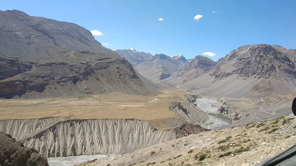
Spiti is a high-altitude region reached by long mountain-road journeys. Kaza is a practical base for nearby villages and monasteries, while Tabo and Dhankar sit farther down the valley. The extraordinary setting is part of the experience, but it also determines the pace: road conditions, acclimatisation and daylight matter more than the number of pins you can collect. Short map distances must never be converted automatically into fast driving times.
Plan the approach before choosing sightseeing. A staged route with suitable overnight elevations gives the body more time to adapt than a rapid ascent from the plains. Neither the Shimla–Kinnaur approach nor a summer crossing from the Manali side should be treated as a routine city transfer. Work through the actual sleeping elevations and current road availability with an experienced local operator, and seek individual medical advice when relevant. The route that appears shorter is not necessarily the right arrival route.
The three plans here are local modules for travellers who have already made a suitable approach; they do not authorise a three-day Delhi-to-Spiti trip. The first is deliberately light. Higher outings are conditional on feeling well and adequate acclimatisation, with time to return to the established base. The suggested nine-day overall allowance is an editorial starting point, not a guarantee that any fixed circuit is safe or feasible. Add time or remove stops when conditions require it.
When should you go?
For a first general sightseeing trip, summer and early autumn are more practical starting points than winter. June still requires confirmation that the chosen approach is open; September still requires road and weather checks. July–August can bring disruption on approach roads even when the inner valley is relatively dry. Winter is specialist travel.
Tap a month for the tradeoff. These are editorial seasonal patterns; weather varies.
JanChallenging
Severe cold and restricted access make this a specialist winter journey.
FebChallenging
Do not use the summer itinerary without winter-specific local arrangements.
MarChallenging
Snow, cold and limited services still demand substantial contingencies.
AprChallenging
Early-season access is route-dependent; a through-circuit is not a default.
MayMixed
Confirm every overnight stop and approach road before reserving a circuit.
JunGood
Useful first-trip window only after verifying the chosen road has opened.
JulMixed
Watch conditions across the entire approach, including lower mountain roads.
AugMixed
Retain buffer days for weather-related disruption and changing road access.
SepGood
A useful planning choice with cold evenings and daily road checks.
OctMixed
Increasing cold and closure risk require a conservative route and flexibility.
NovChallenging
Treat conditions as winter travel rather than late-season summer sightseeing.
DecChallenging
Limited services and snow make a casual first visit a poor fit.
Does it fit your trip?
Five editorial suitability scores, each out of five. Open a category to see the reasoning. These are not visitor averages. How we rate.
Scenery5 / 5
Editorial judgement: high-desert valleys and mountain settlements are the defining strength.
Heritage5 / 5
Living monasteries, village architecture and Buddhist cultural traditions reward patient visits.
Car-free ease1 / 5
Long distances and limited services make tightly scheduled car-free touring difficult.
Family suitability2 / 5
Altitude, road journeys and limited medical access require more preparation than a typical family break.
Value3 / 5
Simple accommodation can be affordable, but transport and essential buffer days add substantial cost.
What is the best way to get around?
The best option depends on the stops you choose. These comparisons explain the tradeoffs; routes, availability and fares need a current check.
HRTC with substantial flexibility
A budget option for travellers able to adapt to limited and seasonal services. Verify the specific route with HRTC and the local bus stand; not every local service appears in online booking. Build overnight stops around acclimatisation, not just a through-ticket.
Usually the most flexible option for these local days. Agree the actual approach, sleeping stops, weather contingencies and return buffer before booking. Ask how delays and route changes are charged, and confirm the driver’s recent experience on the intended roads.
Evaluate the sleeping elevations and daily driving, not the attraction count. Ask about qualified support, communication, emergency arrangements and what happens if a participant becomes unwell. The district’s travel advisory is a useful starting point for questions, not an operator endorsement.
Combine these local day plans or use just one. Stop times are suggested visit allowances, not opening hours or travel times. Leave additional time for meals and transfers.
Plan the approach first. These are local modules after arrival and appropriate acclimatisation. They are not a one-to-three-day trip from a low-altitude city. Include staged travel, rest and weather buffers; read the altitude guidance below.
Day option 1: Kaza: a deliberately light local day after a staged approach
This pin represents the base town, not a named hotel. Rest at your booked accommodation, discuss how you feel and check plans with the host. If unwell, seek appropriate help rather than attempting any of the remaining stops.
Only if comfortable, take a short level-paced errand or meal walk near your accommodation. Avoid adding a climb or driving to the higher villages. Turn back early if tired; the limited duration is intentional.
Choose a nearby host-arranged meal and confirm tomorrow’s road conditions and pickup. The pin is a general town location, not a restaurant endorsement. Keep the evening restful and be willing to repeat a rest day.
Travel from Kaza with an experienced driver and plenty of daylight. Expect steps and a higher elevation; climb slowly, respect rooms closed to visitors and stop the outing if symptoms develop. Interior photography depends on local permission.
Continue only if the group is well and the road is suitable. Keep the village visit short and considerate, remain on public paths and ask before photographing residents. Do not add a trek merely because the vehicle reaches the village.
Reserve the late-day block for a meal and recovery after the separate return drive. Allow roughly two to three hours of total driving for the outing, more if conditions demand. Avoid extending it to a pass crossing or lake camp.
Leave Kaza early only after the route is confirmed. The drive is a substantial part of the day and excluded from this visit allowance. Follow current access and photography rules inside the historic complex; do not schedule a cave climb as an automatic extra.
Take a proper meal and check road and return conditions with your driver. This is the decision point for keeping or dropping Dhankar. If delays have accumulated, return directly to Kaza rather than shortening every remaining safety margin.
Visit only if the access road, daylight and group condition allow the detour. Observe from permitted areas, keep away from unprotected edges and exclude the lake hike. Allow the full return drive to Kaza afterward; this is not the end of the travel day.
CDC guidance favours gradual ascent and mild activity during the first 48 hours at altitude. Fitness does not remove altitude-illness risk. Review sleeping elevations and allow extra nights; this guide’s light Kaza day is not a substitute for an appropriate approach or an individual medical plan.
Know when to stop
Headache with nausea, unusual fatigue or dizziness after ascent may indicate altitude illness. Do not go higher with symptoms. Worsening symptoms despite rest, confusion, poor coordination or breathlessness at rest need urgent medical help and descent. Arrange an emergency plan before entering remote areas.
Confirm the whole road journey
Check recent district and police information plus your local operator immediately before travel. Inspect timestamps: an official road-status webpage can still show an old update. Snow, rockfall or other disruption may affect either approach, so keep a return buffer before flights or work commitments.
Check permits for your actual route
Foreign visitors should confirm current permit and entry requirements with the relevant district authorities before choosing the Shimla–Kinnaur approach or nearby restricted areas. Carry the documents requested for that route. Do not infer that permission for one valley automatically covers every side trip.
Use Kaza to prepare, not to overfill the day
Save essential contacts and maps offline, obtain appropriate cash, confirm fuel and food availability with your operator, and tell your accommodation the day’s plan. Connectivity and payment availability can change; these preparations are more valuable than an extra viewpoint on arrival.
Ask before entering monastery spaces
Monasteries remain places of study and worship. Follow local rules for shoes, photographs and closed rooms, speak quietly and keep drones out unless all required permissions are confirmed. Do not touch murals, manuscripts or religious objects for a photograph.
Pack for cold and strong sun
Carry layers, a windproof outer layer, sun protection and water access arranged with your host. Ask about room heating, hot water, power and toilet arrangements before booking a remote stay. Comfort depends on the actual facilities available, not a generic star rating.
Leave fragile places intact
Stay on established roads and paths, bring waste back to an appropriate collection point and avoid driving over fields or fragile terrain. Do not remove fossils or other natural objects. Wildlife sightings are never guaranteed and should not be pursued by crowding or chasing animals.
Understand these three local modules
Visit durations exclude driving and are approximate. The Key–Kibber outing needs a separate driving allowance; the Tabo–Dhankar day can require roughly four to six hours of driving in addition to visits, sometimes longer. Ask the driver to revise the day and drop Dhankar if conditions make the return rushed.
Your questions, answered
Can I visit Spiti in three days?
Three days can describe local exploration after a suitable approach and acclimatisation, as in these modules. They are not a realistic complete first trip from Delhi or the plains. Allow substantially more time for staged access, the return and disruption; nine days is only a starting allowance.
Is the Manali route always open in summer?
No calendar month guarantees an open road. Confirm the actual route with recent official information and local operators, and check the timestamp on any status page. Keep an alternative and enough buffer to avoid being forced into a drive that conditions do not support.
Should I add Chandratal to these days?
Treat Chandratal as a separate, higher-altitude extension requiring suitable access, acclimatisation, weather and permitted arrangements. It is not included in these local plans. Do not attach a lake visit or overnight camp to a full Kaza sightseeing day simply because a tour package does so.
Your own field notes
Visited? Record your personal category ratings for next time. They stay on this device and are not published or counted as visitor reviews.
Sources & editorial notes
Researched for TheLazyNick using the sources below. This is a source-based planning guide, not a claim of a personal visit. The suggested routes, timings and suitability scores are editorial judgements.
Source check: . Check live notices before setting off.
Distances are straight-line estimates between catalogue pins, within 30 km. Roads, entrances and walking routes may be much longer. Known closed places are excluded; inclusion does not confirm opening today.
By Nikhil (Nick) · Editorial notes updated . First-person account from Nick's filmed 29 September–6 October 2024 motorcycle trip; current journey planning is separate.
I went to Spiti for Chandrataal. On day five in Kaza, the organisers told us a motorsport rally would close the route to the lake. That uncertainty became the centre of my film, because the destination I cared about most suddenly seemed out of reach. We waited for an opening, crossed Kunzum La, stopped in the Batal area and finally reached the shore the following morning. The itinerary on this site preserves that sequence instead of smoothing it into a perfect tour.
We rode from Chandigarh through Kinnaur on Royal Enfield Himalayans, returning by Manali between 29 September and 6 October 2024. The first day included a missed turn and thick fog near Narkanda. The second brought gravel, my first fall and a late arrival near Chitkul. Seeing that approach in daylight the next morning changed how I felt about having ridden it in darkness. Those moments are useful context for the guide: a modest-looking distance does not explain the attention a mountain day can demand.
The camera records more than the views I had hoped to bring home. The bike tipped onto my boot in the sloping Kaza hotel parking area, and I fell again near Hikkim. After Chandrataal, a car struck my front tyre on the road towards Manali and knocked me down. I was unhurt and covered in dust. I include those incidents because they belong to the actual journey, rather than presenting the landscape as if the travelling between the photographs were effortless.
For the map, the route has been reconstructed from camera GPS, OpenStreetMap tracks and routing between the stops. The roughly 1,173-kilometre total is an estimate, not an odometer reading. Some overnight property names remain unidentified, so the published account names the areas instead of attaching an uncertain booking link. I want someone watching the film to be able to follow the journey while still recognising which details the footage and records can establish and which they cannot.
My practical lesson is to leave room for the route to change. Check current roads, events, permits and local advice before planning a new trip, and agree how a group will regroup if people become separated. The conditions of our ride are a record of 2024, not a live road report. Read the longer trip story beside the film for the daily sequence, then use the separate planning guidance for your own dates and circumstances. Reaching the lake mattered to me; having time and options to get there mattered too.